Comparison with GONG and HMI farside maps.
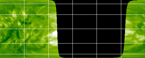
Shown here is a side-by-side comparison between the
latest SECCHI beacon images
and the most recent
calibrated farside
maps from the
Global Oscillation Network
Group (GONG), and the
Solar Dynamic
Observatory (SDO)
Helioseismic and Magnetic
Imager (HMI).
|
|
EUVI image revised: Monday, 23-Feb-2026 13:20:14 EST
|

|
|
Image courtesy GONG project.
|
The
farside
maps are based on an analysis of sound wave travel time variations, with
locations of shorter travel times appearing darker. These darker regions
indicate locations where there is an accumulation of magnetic field on the far
surface
(farside information and references).
Candidates with a probability of 70% or higher are highlighted in
red
(more information).
For comparison, here is a similar analysis of
SDO/HMI farside data, in a
somewhat different format. The black and white areas show magnetic field
strength and polarity, while the orange regions show the helioseismology
results for the far side. (Note also that a different map projection is
used, evenly spaced by latitude instead of by sine latitude.)

|
|
Image courtesy SDO/HMI project.
|
Last Revised: Tuesday, 25-Nov-2025 11:58:33 EST
Responsible NASA Official: ![[email address: therese.a.kucera<at>nasa<dot>gov]](/img/kucera_email.jpg)
Privacy Policy and Important Notices
Accessibility
Webmaster: Apexa Patel
|